
The National Oceanic and Atmospheric Administration (NOAA) National Weather Service (NWS) has a mandate to provide hydrologic forecasts to the Nation. Operational river forecasts are generated using a hydrologic modeling system at 13 River Forecast Centers (RFCs) throughout the country on a continuous basis for approximately 4,000 river locations.
Evaporation is a key element of the hydrologic modeling system. Accurate estimation of evaporation is critical in predicting streamflow and flood magnitudes and timings. Incoming solar radiation is blocked by clouds, and changes the evaporation substantially on cloudy days. Therefore cloud cover is an integral part of NOAAs modeling system.
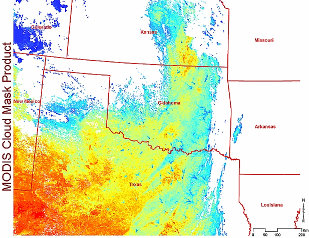
During 1990s, NOAA commissioned Automated Weather Observing System (ASOS) to replace hourly manual observations throughout the country with automated observations. ASOS is a reliable system, but has some limitations as well. The cloud cover product from ASOS is limited to 12000 ft above ground, so evaporation estimates from ASOS data does not account for clouds above that height. Because of this, National Weather Service River Forecast System (NWSRFS) does not use the ASOS cloud datasets in their modeling and thus have lost previously available functionality due to discontinued cloud cover observations needed in evaporation computations. Replacement of those observations is NOAA Hydrology Labs top priority, and that could be accomplished with remote observations from space. NASAs cloud mask product derived from the Moderate Resolution Imaging Spectroradiometer (MODIS) can be used to replace discontinued ground observations of cloud cover
This project:
The overarching goal of the work is the demonstration of improved accuracy in runoff, stream flow, and flood monitoring and simulation that result from the combination of NASA data and model infrastructure with operational NWSRFS decision support tools.
What:
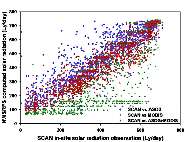
We are merging MODIS cloud mask products (available twice during daytime) with more frequent (hourly), but less accurate ASOS cloud cover estimates. We have verified that the merged product meets the technical specifications of the decision support system. Comparisons of the solar radiation estimated by NWSRFS using the merged ASOS+MODIS cloud product shows an excellent correlations with an independent solar radiation estimate (US Department of Agricultures Soil Climate Analysis Network (SCAN) sites)
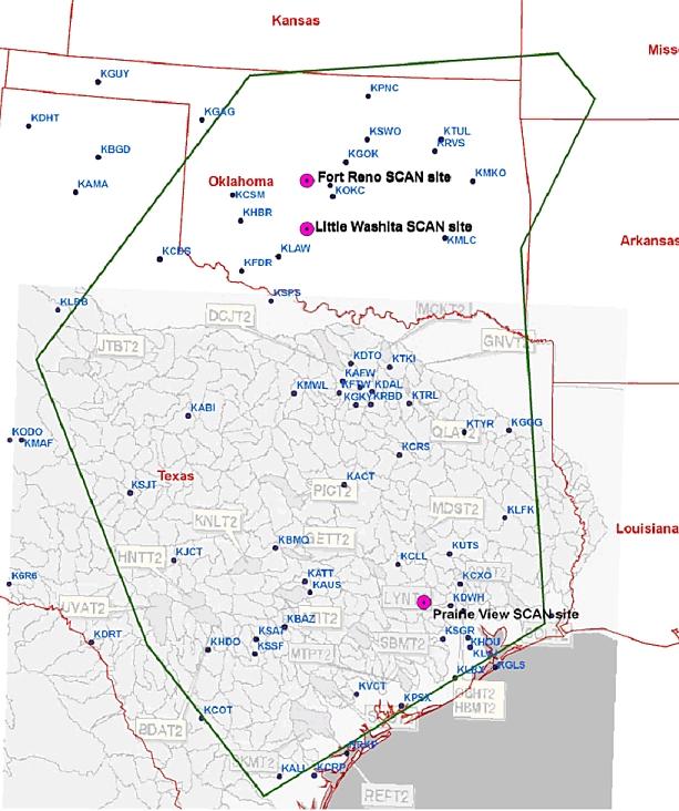
The integrated, merged product is being benchmarked at some of the watersheds shown in the study area (below) in cooperation with the NOAA scientists. Early results show that the spring and summer streamflow estimation is improved by as much as 15% using the merged products. We are currently undergoing a comprehensive assessment of the merged cloud product performance in the NWSRFS.
Future work
It is expected that guidance products produced by the engineering and integration of NASA satellite- derived datasets will provide NOAA/NWS RFC hydrologists with a more accurate basis for decision-making and hydrologic warning product generation.
NOAA is developing the suite of next generation operational hydrologic models. The distributed model will be better suited to ingest the NASA datasets. We are working closely with the NOAA hydrologists to make NASA datasets integral part of the next generation models.
Technical Contact: Dr. Doug Rickman (Douglas.L.Rickman@nasa.gov)
Responsible Official: Dr. James L. Smoot (James.L.Smoot@nasa.gov)
Page Curator: Diane Samuelson (diane.samuelson@nasa.gov)