NASA SPoRT’s streamflow product predicts flood of record event from Hurricane Ian days in advance
Time is everything to an operational weather forecaster. The more lead time a forecaster has to predict catastrophic weather events, the earlier the public can be warned and protected.
NASA SPoRT’s streamflow product was created to provide a two to seven day forecast for flooding events. In the week leading up to the storm, NASA SPoRT’s streamflow product proved to be a trusted source in successfully predicting a flood of record event from Hurricane Ian.
On September 23, 2022 at 0600Z, NASA SPoRT’s streamflow product indicated a potential flood of record for the Little Wekiva River near Altamonte Springs, Florida on September 29th, 2022 at 0000Z as shown in Figure 1. Thanks to the forecast provided by NASA SPoRT’s streamflow product, the National Weather Service (NWS) of Melbourne, Florida had guidance more than five days in advance of the potential for historic flooding that occurred at the Little Wekiva River.
“We were monitoring NASA SPoRT’s experimental river level forecasts leading up to the event. The streamflow product gave us a heads up several days in advance of the storm for the potential of significant river flooding along the Little Wekiva River,” said Matthew Volkmer the Science and Operational Officer of the NWS of Melbourne, Florida.
NASA SPoRT’s streamflow product integrates Quantitative Precipitation Forecasts (QPFs) from the Weather Prediction Center (WPC), National Blend of Models (NBM), and the Global Forecast System (GFS), as well as NASA SPoRT’s Real-Time Land Information System (LIS) Relative Soil Moisture data, and observations from the United States Geological Survey (USGS) river gauges. From these inputs, NASA SPoRT’s streamflow product uses machine learning (ML) to analyze patterns and predict future stream heights of various rivers and creeks across the United States.

Figure 1. On September 23, 2022 at 0600Z, NASA SPoRT’s streamflow product indicated a potential flood of record for the Little Wekiva River to occur on September 29th, 2022 at 0000Z.
On September 28, 2022 near 0000Z, the Little Wekiva River’s USGS river gauge observed a rapid rise in flood stage due to excessive rainfall from the outer bands of Hurricane Ian. Heavy rainfall continued where the Little Wekiva River crested to a historic record of 31.09 feet at 0430Z on September 29th, 2022. According to the Multi-Radar/Multi-Sensor System (MRMS) Quantitative Precipitation Estimation (QPE), the Little Wekiva River basin experienced rainfall totals that exceeded 10+ inches from 0000 UTC September 28, 2022 to 0000Z September 30, 2022 as shown in Figure 2.

Figure 2. Multi-Radar/Multi-Sensor System (MRMS) Quantitative precipitation estimation (QPE) from 0000Z September 28, 2022 to 0000Z September 30, 2022 for the Little Wekiva River in Altamonte Springs, FL.
When comparing the Little Wekiva River’s NASA SPoRT’s streamflow ML model to its USGS observations in Figure 3, they match reasonably well. This comparison, along with accurately indicating a potential for a flood of record five days in advance, shows the value of NASA SPoRT’s streamflow product as being a trusted source when predicting future flooding events.

Figure 3. An overlay of NASA SPoRT’s streamflow product forecast and the observations from the USGS river gauge of the Little Wekiva River (black line).
About SPoRT
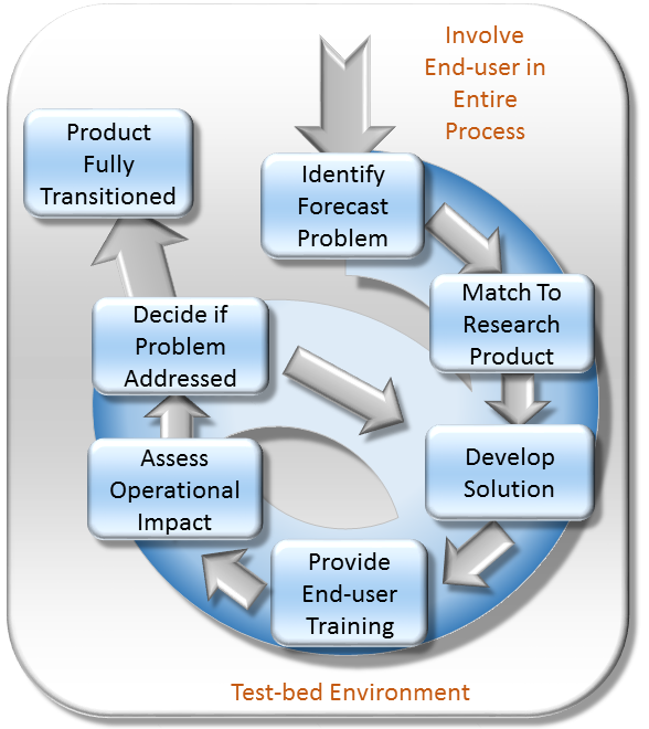
The Short-term Prediction Research and Transition (SPoRT) center at NASA's Marshall Space Flight Center in Huntsville, AL is a NASA-funded activity with a vision of accelerating the translation of NASA science to applications by collaborating with researchers, innovators, and stakeholders. SPoRT was established in 2002 and is funded under the NASA Earth Science Division Research and Analysis Program’s Weather and Atmospheric Dynamics Focus Area. Therefore, SPoRT’s early focus was on transitioning NASA products to the operational weather community to improve short-term forecasting with end users within the operational weather community (e.g. National Oceanic and Atmospheric Administration National Weather Service). Today SPoRT focuses on applied research and applications in 6 focus areas that span weather, atmospheric, and land surface topics with partnerships across government, academia, and the private sector (see Collaborative Partners). A research-to-operations/operations-to-research paradigm (figure below) has been the basis for transitioning over 40 satellite products to stakeholders over 20 years. The main goals of the SPoRT paradigm include (1) early and intentional interaction with stakeholders, (2) identifying and/or developing user-driven science solutions from NASA observations and research capabilities, (3) timely delivery of data products for early stakeholder testing and feedback, (4) integration of data products and capabilities in user formats, visualizations, and display systems, (5) targeted applications-based training highlighting use cases, examples, product advantages and limitations, (5) stakeholder assessments and product testing, and (6) prioritizing operations to research feedback to meet users’ needs and facilitate the sustained use of NASA data in applications. The SPoRT paradigm enables intentional interaction between scientists and stakeholders throughout the research-to-applications/applications-to-research lifecycle to develop innovative solutions through an iterative process that meet stakeholder needs, are tailored for their application, and promote sustained use of NASA observations and research capabilities. SPoRT values innovation, collaboration, and engagement to bridge the gap between science and applications and maximize the benefit of NASA data for operations, applications, and decision making.

Responsible Official: Dr. Andrew Molthan (andrew.molthan@nasa.gov)
Page Curator: SPoRT Support (msfc-dl-sport-support@mail.nasa.gov)
Support Disclaimer