Extremely Warm Sea Surface Temperatures Increases Confidence for an Active Hurricane Season

Image Caption: NASA Short-term Prediction Research and Transition (SPoRT) Sea Surface Temperature product shows exceedingly warm temperatures throughout the Gulf of Mexico, a key ingredient that could help fuel an active hurricane season this year.
Since June 2023, NASA’s Short-term Prediction Research and Transition (SPoRT) Sea Surface Temperature product has observed extremely warm Gulf of Mexico water temperatures ranging between 27-33 degrees Celsius, which is equivalent to upper 80’s to lower 90’s degrees Fahrenheit.
Dr. Patrick Duran, Lead Tropical Cyclone Research Scientist for NASA SPoRT and the Deputy Applications Lead for NASA’s TROPICS mission says persistent high pressure over the Gulf of Mexico is the main driver causing extremely warm Gulf water temperatures.
“High pressure suppresses cloud cover, leading to more sunshine which warms the Gulf waters,” says Duran.
High pressure systems are also known to weaken surface winds, which limits vertical mixing of surface water with cooler water below, also helping to keep sea surface temperatures warm.
Duran states warm Gulf waters is a key ingredient that helps hurricanes maintain or rapidly intensify while approaching landfall.
In fact, it could help hurricanes to maintain their strength regardless of the recently declared El Nino pattern in effect for Summer 2023, which is known to hinder hurricane formation and intensification in the Gulf of Mexico, Atlantic, and Caribbean due to an increase in vertical wind shear.
About SPoRT
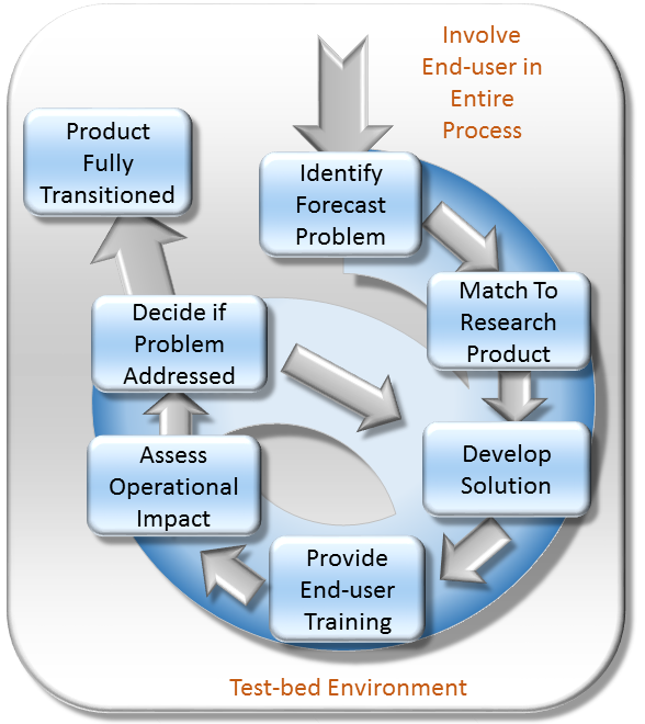
The Short-term Prediction Research and Transition (SPoRT) center at NASA's Marshall Space Flight Center in Huntsville, AL is a NASA-funded activity with a vision of accelerating the translation of NASA science to applications by collaborating with researchers, innovators, and stakeholders. SPoRT was established in 2002 and is funded under the NASA Earth Science Division Research and Analysis Program’s Weather and Atmospheric Dynamics Focus Area. Therefore, SPoRT’s early focus was on transitioning NASA products to the operational weather community to improve short-term forecasting with end users within the operational weather community (e.g. National Oceanic and Atmospheric Administration National Weather Service). Today SPoRT focuses on applied research and applications in 6 focus areas that span weather, atmospheric, and land surface topics with partnerships across government, academia, and the private sector (see Collaborative Partners). A research-to-operations/operations-to-research paradigm (figure below) has been the basis for transitioning over 40 satellite products to stakeholders over 20 years. The main goals of the SPoRT paradigm include (1) early and intentional interaction with stakeholders, (2) identifying and/or developing user-driven science solutions from NASA observations and research capabilities, (3) timely delivery of data products for early stakeholder testing and feedback, (4) integration of data products and capabilities in user formats, visualizations, and display systems, (5) targeted applications-based training highlighting use cases, examples, product advantages and limitations, (5) stakeholder assessments and product testing, and (6) prioritizing operations to research feedback to meet users’ needs and facilitate the sustained use of NASA data in applications. The SPoRT paradigm enables intentional interaction between scientists and stakeholders throughout the research-to-applications/applications-to-research lifecycle to develop innovative solutions through an iterative process that meet stakeholder needs, are tailored for their application, and promote sustained use of NASA observations and research capabilities. SPoRT values innovation, collaboration, and engagement to bridge the gap between science and applications and maximize the benefit of NASA data for operations, applications, and decision making.

Responsible Official: Dr. Andrew Molthan (andrew.molthan@nasa.gov)
Page Curator: Paul Meyer (paul.meyer@nasa.gov)
Support Disclaimer