Flood Preparedness in Texas with NASA SPoRT's Streamflow-AI
For over two decades, the NASA Short-term Prediction Research and Transition Center (SPoRT) within the NASA Earth Science Office at Marshall Space Flight Center has been at the forefront of developing and maintaining decision-making tools for meteorological predictions. Jonathan Brazzell, a service hydrologist at the National Weather Service (NWS) office in Lake Charles, Louisiana, highlighted a recent example of SPoRT's impact while he was doing forecasting for Texas streams.
Brazzell, who manages the South Texas and South Louisiana regions, emphasized the practical applications and significant impacts of the Machine Learning (ML) model developed by NASA SPoRT to predict future stream heights, known as the SPoRT Streamflow A.I. During a heavy rainfall event this past spring, he noted the challenge of forecasting flooding beyond 48 hours. SPoRT has worked closely with the NWS offices to develop a machine learning tool capable of predicting river flooding beyond two days and powered by the SPoRT Land Information System (LIS). Brazzell explained, “Previously, we relied on actual gauge information and risk assessments based on predicted precipitation. Now, with this machine learning, we have a modeling tool that provides a much-needed predictive capability.”
During forecasted periods of heavy precipitation from early to mid-May, Brazzell monitored potential flooding events and their magnitude using NASA SPoRT’s Streamflow-AI, which provided essential support to the Pine Island Bayou and Big Cow Creek communities in south Texas.
Streamflow A.I. enabled local authorities to provide advance notice, allowing residents to prepare adequately for the event. Due to the benefit of 3 to 7-day flood stage predictions, the accurate forecasts helped county officials decide on road closures and evacuation advisories; community officials advised residents to gather a 7-day supply of necessities and relocate their vehicles, minimizing disruption and potential damage.
Brazzell highlighted specific instances where the machine learning outputs were critical. For example, during the event that peaked around May 6th, Streamflow A.I. accurately predicted the rise in stream height, allowing for timely road closures and advisories. These predictions were shared with county officials and were pivotal in their decision-making process.
Brazzell shared that integrating SPoRT's machine learning capabilities with their existing tools, such as flood risk mapping, proved invaluable. Although the machine learning outputs had been operational for almost two years after Hurricane Harvey, this season has provided their first significant applications in real-time scenarios due to persistent conditions of below-normal precipitation and ongoing drought.
He also mentioned the broader applications of Streamflow A.I., including its potential use in other sites beyond those currently being monitored. He expressed interest in expanding the use of machine learning stream height outputs to additional locations, citing the successful application in current sites as a compelling reason for broader implementation.
NASA SPoRT users' experiences emphasize how crucial advanced prediction technologies are in hydrometeorology and emergency management operations. Based on Brazzell's example, it is reasonable to say that the product’s ability to provide accurate, timely data greatly improves decision-making processes and ensures public safety. The partnership between NASA SPoRT and operational agencies like NOAA/NWS and county response teams demonstrates how research and operations can be seamlessly integrated into everyday practices, making a tangible difference in communities vulnerable to high-impact events.
As the Streamflow A.I. product continues to evolve and expand its applications, it holds significant promise for improving disaster preparedness and response efforts across various regions that experience different types of flooding events.
The Streamflow-AI product provides a 7-day river height or stage forecasts at select gauges across the south/eastern U.S. You can find the SPoRT training item on Streamflow-AI here, NASA SPoRT Streamflow-AI Training.
See below the images from the Streamflow A.I. product during this weather event:

This image represents the first instance of predictions getting into moderate flooding in Pine Island Bayou. At 14ft (start of the moderate flooding category), Cooks Lake Road becomes unsafe for most vehicles.

This image shows the water levels after rainfall and predicts a moderate stream height in Pine Island Bayou.
About SPoRT
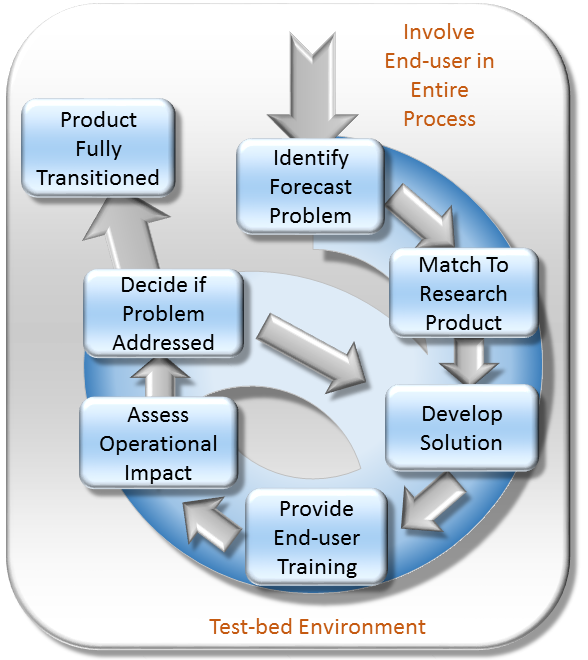
The Short-term Prediction Research and Transition (SPoRT) center at NASA's Marshall Space Flight Center in Huntsville, AL is a NASA-funded activity with a vision of accelerating the translation of NASA science to applications by collaborating with researchers, innovators, and stakeholders. SPoRT was established in 2002 and is funded under the NASA Earth Science Division Research and Analysis Program’s Weather and Atmospheric Dynamics Focus Area. Therefore, SPoRT’s early focus was on transitioning NASA products to the operational weather community to improve short-term forecasting with end users within the operational weather community (e.g. National Oceanic and Atmospheric Administration National Weather Service). Today SPoRT focuses on applied research and applications in 6 focus areas that span weather, atmospheric, and land surface topics with partnerships across government, academia, and the private sector (see Collaborative Partners). A research-to-operations/operations-to-research paradigm (figure below) has been the basis for transitioning over 40 satellite products to stakeholders over 20 years. The main goals of the SPoRT paradigm include (1) early and intentional interaction with stakeholders, (2) identifying and/or developing user-driven science solutions from NASA observations and research capabilities, (3) timely delivery of data products for early stakeholder testing and feedback, (4) integration of data products and capabilities in user formats, visualizations, and display systems, (5) targeted applications-based training highlighting use cases, examples, product advantages and limitations, (5) stakeholder assessments and product testing, and (6) prioritizing operations to research feedback to meet users’ needs and facilitate the sustained use of NASA data in applications. The SPoRT paradigm enables intentional interaction between scientists and stakeholders throughout the research-to-applications/applications-to-research lifecycle to develop innovative solutions through an iterative process that meet stakeholder needs, are tailored for their application, and promote sustained use of NASA observations and research capabilities. SPoRT values innovation, collaboration, and engagement to bridge the gap between science and applications and maximize the benefit of NASA data for operations, applications, and decision making.

Responsible Official: Dr. Andrew Molthan (andrew.molthan@nasa.gov)
Page Curator: SPoRT Support (msfc-dl-sport-support@mail.nasa.gov)
Support Disclaimer