LIS soil moisture for Drought and Flood
Description:
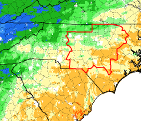
NASA Land Information System (LIS) output of sub-surface soil moisture was applied to analysis of drought and potential areal flooding. Forecasters from Huntsville, Raleigh, and Houston evaluated several layers of quantitative and relative moisture fields including a 1-week change product.
Participants: HGX, HUN, RAH
Language: English
Publication Date: ?
Season: 15 July- 31 October 2014
Forecast Challenge: modeling flood and drought potential
Categories: Local Modeling, GFS, MODIS GVF