Advanced Weather Interactive Processing System Evolution Project (AWIPS II)
A primary key to SPoRT's success has been SPoRT's ability to transition unique NASA Earth observing system data directly into the decision support systems of our end users. Primarily, this is the National Weather Service and their Advanced Weather Interactive Processing System (AWIPS). The expertise SPoRT has developed, with support from our National Weather Service partners has allowed a wide range of unique products to be viewed in near- to real-time operations in AWIPS. Today, the National Weather Service, through its contractor, Raytheon, is developing the successor of AWIPS with the AWIPS Evolution Project (AWIPS II). To maintain our collaboration with our National Weather Service partners, SPoRT has been working with a demonstration version of AWIPS II since March 2008 to learn how to bring the SPoRT product suite to the AWIPS II environment.
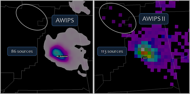
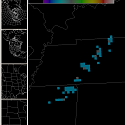
Figure 1. A comparison of total lightning data for the same storm in AWIPS (left) and AWIPS II (right). The AWIPS display automatically smoothes the lightning data. This causes a reduction in the maximum value (86 sources) with respect to AWIPS II (113 sources). Additionally, the circled region indicates where the smoothing of data in AWIPS would prevent the forecaster from seeing the spatial extent of lightning as seen in AWIPS II.
The current AWIPS environment is rigid, making it difficult to incorporate new and unique data sets, particularly those that were not envisioned when AWIPS was first developed. One example of this difficulty is in the transition of total lightning data. Data from the North Alabama Lightning Mapping Array have to be formatted to mimic more standard product types in AWIPS, since the system does not yet have the flexibility to accommodate these data. This "shoe-horning" of total lightning data results in a loss of data fidelity, as the current AWIPS smoothes the data. AWIPS II addresses these concerns by creating a more flexible system that uses JAVA plug-ins to bring in more datasets, including other future datasets. Figure 1 shows an example of the greater fidelity provided by AWIPS II versus AWIPS for a thunderstorm observed by the North Alabama Lightning Mapping Array. The AWIPS II display does not smooth the data and therefore better shows the magnitude of the lightning as well as the spatial extent; both of which are important to improved lightning safety. Another data fidelity advantage is with the MODIS products. Currently, the MODIS products are processed in McIDAS and then must be transformed to an AWIPS-friendly format. The plug-in capability of AWIPS II removes the need of this interim step. With support from the Huntsville Weather Forecast Office, a McIDAS plug-in has been developed that allows AWIPS II to natively view McIDAS area files. This direct display capability reduces any potential problems that can arise from data format changes.
RESEARCH
There are additional advantages to the AWIPS II display environment that SPoRT is learning to use to create enhanced visualizations of SPoRT data. As an example, newer graphics hardware allows AWIPS II to introduce a powerful zoom and pan feature, similar to Google Earth. For the existing AWIPS display, SPoRT must take the MODIS data and divide it into individual sectors for each National Weather Service partner. The AWIPS II display may remove the need for this sector processing. This provides SPoRT an avenue to product unique NASA data to more collaborators as the processing needs to produce products are greatly reduced. Additionally, SPoRT looks forward to the implementation of new cross-section and three-dimensional viewing software to determine how best this can be applied to the existing SPoRT product suite.
For more information about the AWIPS II project, pleast visit the AWIPS Technology Infusion home page, part of NOAA's Office of Science and Technology.
Additional information about the developer, Raytheon, can be found at Raytheon's AWIPS home page.


