AIRS 3D Moisture Analysis
|
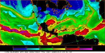
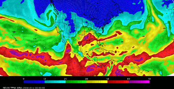
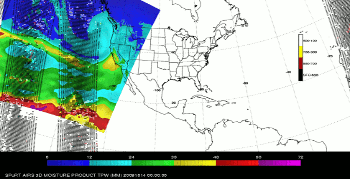
The dearth of upper air observations over the Pacific Ocean can lead to model initializations that contain very little observational data and revert to the background field. While this may be adequate, improvements in the initial conditions can yield improved forecasts. One particular forecast challenge for WFOs in Alaska, the Pacific and the West Coast of the United States is obtaining a correct moisture analysis over the Pacific Ocean. Streams of moisture called atmospheric rivers can stream ashore the North American Coastline and produce intense rainfall due to orographic lifting and may not be well-represented in models and analyses. Currently, some offices are using a total precipitable water (TPW) product from CIRA that SPoRT has helped transition to the operational community. This product blends various satellite and GPS observations of TPW into a blended product that can be used to track atmospheric rivers and other moisture features. However, this particular product is not available to be used in model initialization. An additional source of satellite atmospheric moisture observations comes from NASA's AIRS hyperspectral sounder. AIRS is able to see temperature and moisture in clear and partly cloudy conditions and produce vertical profiles of temperature and moisture. SPoRT is currently blending a GDAS analysis with AIRS temperature and moisture observations over the Pacific using the Gridpoint Statistical Interpolation (GSI) data assimilation system to produce a three-dimensional moisture analysis product. Figures 1-3 show an example of the SPoRT AIRS 3D Moisture Analysis Product is given below for an atmospheric river case on 14 October 2009 that impacted the Western United States. In this example, the CIRA TPW (Figure 1) is taken as the observed state of the atmosphere. The GDAS analysis (Figure 2) used to initialize the 00Z GFS shows the TPW pattern consistent with the atmospheric river; however, the atmospheric river is too wide and is slightly more intense than indicated in the CIRA TPW product. Additionally, the areas surrounding the atmospheric river are too moist compared to the CIRA product. Upon assimilation of the AIRS temperature and moisture profiles (Figure 3), the width of the atmospheric river tightens and the surrounding areas are dried. The resulting 3D analysis compares more favorably to the CIRA TPW product. Further testing is needed on additional case studies. Current work is focusing on establishing collaborations with the Hydrometeorological Testbed (HMT) to provide the analysis product and forecasts for case studies that have been tested by that organization in the past. If the results of these cases prove as impactful as the one above, SPoRT will begin transitioning a near-real-time version of this product to select NWS WFOs in Western, Pacific, and Alaska Region for further evaluation. Future iterations of this same product will assimilate profile data from the Infrared Atmospheric Sounding Interferometer (IASI) and Cross-track Infrared Sounder (CrIS) using lessons learned from AIRS to produce an analysis valid at multiple times during the day. |
 Figure 1. CIRA TPW product from 2301 UTC on 13 October 2009 depicting strong atmospheric river impacting the California coast. |


