

AIRS Radiance/Profile Comparison
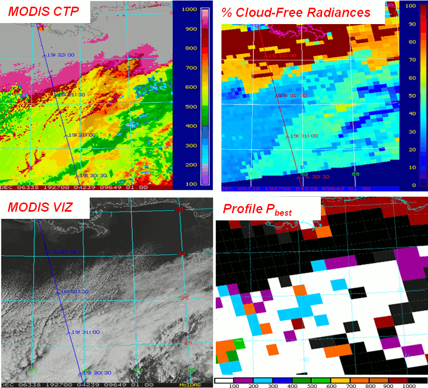
Figure 1. Comparison between MODIS CTP (upper left) and cloud location as determined by MODIS visible imagery (bottom right) to the number of cloud-free AIRS radiances assimilated (top right) and the amount of AIRS profile data that can be assimilated (bottom right).
Improvements to global and regional numerical weather prediction (NWP) have been demonstrated through assimilation of data from NASA's Atmospheric Infrared Sounder (AIRS). Current operational data assimilation systems use AIRS radiances, but impact on regional forecasts has been much smaller than for global forecasts. Retrieved profiles from AIRS contain much of the information that is contained in the radiances and may be able to reveal reasons for this reduced impact. Assimilating AIRS retrieved profiles in an identical analysis configuration to the radiances, tracking the quantity and quality of the assimilated data in each technique, and examining analysis increments and forecast impact from each data type can yield clues as to the reasons for the reduced impact. By doing this with regional scale models individual synoptic features (and the impact of AIRS on these features) can be more easily tracked.

Figure 2. GOES-13 water vapor image over the Northwestern Gulf of Mexico with cartoon of AIRS radiance coverage using current 120-km resolution operational methodology (top) and higher data density, which retains every third radiance (~45-km resolution; bottom). Red dots are cloud-free radiances, black dots are cloudy radiances, blue dots are radiances with information above clouds, yellow dots are observations influenced by surface emissivity, and green points are observations where additional channels could be added by improved cloud determination.
This project is a collaboration between SPoRT and the Joint Center for Satellite Data Assimilation (JCSDA) to examine the assimilation of hyperspectral sounder data used in operational numerical weather prediction by comparing operational techniques used for AIRS radiances and research techniques used for AIRS retrieved profiles. Parallel versions of a configuration of the Weather Research and Forecasting (WRF) model with Gridpoint Statistical Interpolation (GSI) that mimics the analysis methodology, domain, and observational datasets for the regional North American Mesoscale (NAM) model run at the National Centers for Environmental Prediction (NCEP)/Environmental Modeling Center (EMC) will be run to examine the impact of each type of AIRS data set. The first configuration will assimilate the AIRS radiance data along with other conventional and satellite data using techniques implemented within the operational system; the second configuration will assimilate AIRS retrieved profiles instead of AIRS radiances in the same manner.
Each set of analyses for a series of consecutive forecasts will be examined in the context of the location and magnitude of the impact of the AIRS observations. In and around cloud features and near the surface, AIRS radiance observations may be removed from the analysis, but AIRS profiles may be assimilated. The assimilation of retrieved profile in interesting weather features (such as clouds) may help understand how more information can be exploited from the AIRS radiances. To examine this, the AIRS quality indicator (Pbest) and cloud top pressure (CTP) along with CTPs from the Moderate-resolution Imaging Spectroradiometer (MODIS) can be used along with output from the GSI cloud-detection algorithms to determine whether additional radiances might be able to be assimilated. This process is represented in Figure 1 for a sample day.
Additionally, to increase computational time to meet operational constraints, radiance observations are thinned by performing a subsampling approach that takes every nth observation, so that the resolution of the observations is 120-km. This removes much of the horizontal detail in the AIRS observations that may help capture important weather features in and around clouds. An additional test in this project will be to increase the resolution of the assimilated observations to increase the number of radiances that might otherwise be assimilated. Figure 2 shows how the new distribution of observations may look compared to the current operational configuration.