High-Resolution Rapid Refresh for Alaska
Since 2010, the Arctic Region Supercomputing Center (ARSC) has been running a prototype High-Resolution Rapid Refresh for Alaska (HRRRAK), serving as an Alaska counterpart for the CONUS High Resolution Rapid Refresh (HRRR), now being run operationally by NCEP. The 24-36 hour model forecasts are generated at 3km grid resolution, receiving initial conditions from the 13km heavily-assimilated Rapid Refresh (RR) and lateral boundary conditions from the 11km Alaska North American Mesoscale (NAM) model. After significant pre-processing the model utilises 256 processors for almost twelve hours, sending output in real-time to the National Weather Service Alaska Region Headquarters, with additional post-processing of graphics and verification products for archival purposes. The majority of this work has been unfunded, but NCAR's Developmental Testbed Center has supported the development of verification products and initial exploration of GSI data assimilation into the forecasts.
Through small project funding from Alaska NASA EPSCoR, and guidance from NASA SPoRT, the work has expanded to offering an additional, parallel forecast that uses AIRS profile products to assimilate into the HRRRAK initial conditions (referred to as AIRSAss). Currently still considered experimental, the purpose of these dual forecasts is to compare, over the long term, with minimal degrees of freedom, a non-assimilated HRRRAK forecast with a HRRRAK forecast that has had AIRS profiles assimilated into its initial conditions. A 00Z HRRRAK forecast is generated every day and, before this finishes, the AIRS profiles are ingested and assimilated into the intial conditions file of the HRRRAK forecast, and then used to drive the same forecast, with the same model and configurations so that, at the end of 24 hours both 00Z HRRRAK and AIRSAss model products are available for comparison.
The model system is based on WRF v3.3.1, using...
- 51 Eta levels: 1.0000, 0.9980, 0.9940, 0.9870,...
- Approximate heights of vertical levels (in meters): 8, 31, 74, 149, 259, 403,...
- mp_physics: WSM 3-class simple ice
- ra_lw_physics: RRTM
- ra_sw_physics: Dudhia
- sf_sfclay_physics: MYNN
- sf_surface_physics: Noah LSM
- bl_pbl_physics: MYNN 2.5 level TKE
Verification products, similar to those produced for the HRRRAK are available in the form of...
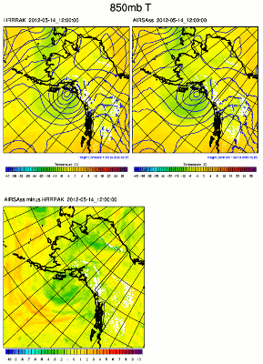
Additionally, for each HRRRAK / AIRSAss forecast pair, 700mb RH and 850 T are compared and "diffed", as Figure 1 shows, comparing Forecast Hour 12 850mb temperatures.


