Local Model Forecasts with SPoRT SST Data
Modeling Sensitivity Studies
The use of high-resolution Moderate resolution Imaging Spectrometer (MODIS) Sea Surface Temperature (SST) composite
products (Haines et al. 2007)
to initialize the Weather Research and Forecast (WRF) model has been shown to improve the prediction of sensible
weather parameters in coastal regions
(LaCasse et al. 2008).
LaCasse et al. (2008) presented notable changes to the sensible heat flux, planetary boundary layer heights,
and convergence zones resulting from pressure gradient accelerations induced by the better-resolved SSTs. In an
extended study,
Case et al (2008)
compared the MODIS SST composite product to the NCEP Real Time Global (RTG) SST analysis
(Thiébaux et al. 2003)
and evaluated forecast differences for a 7-month period from February through August 2007 over the south Florida
coastal region. The NWS WRF Environmental Modeling
System (EMS;
Rozumalski 2010)
framework was employed in Case et al. (2008) to duplicate the model configuration of SPoRT NWS partner offices;
in this case, the NWS Miami, FL forecast office.
Figure 1 shows a plot of WRF-initialized RTG SSTs, MODIS SSTs, and latent heat flux differences from sample forecasts initialized at 1500 UTC 21 March 2007 and 18 August 2007. The RTG SST shows a smoothly-varying field with ~4°C temperature increase from north to south off the west coast of Florida and only ~1°C variation off the east coast, with little variation around the shallower waters of the western Bahamas (Figure 1a). In contrast, the MODIS-initialized SSTs show a very distinctive gradient of 2-3°C over a short distance on either side of the well-defined Gulf Stream current from the Florida Straits south of the Keys to the east of the Florida east coast (Figure 1b). A narrow wedge of cool SSTs hugs the east coast to the north of Lake Okeechobee over the Florida-Hatteras Shelf. Noticeably cooler MODIS SSTs are also found in the shallows of the western Bahamas. In general, the largest differences in SST are well-correlated within the regions of the shallowest ocean bottom topography.
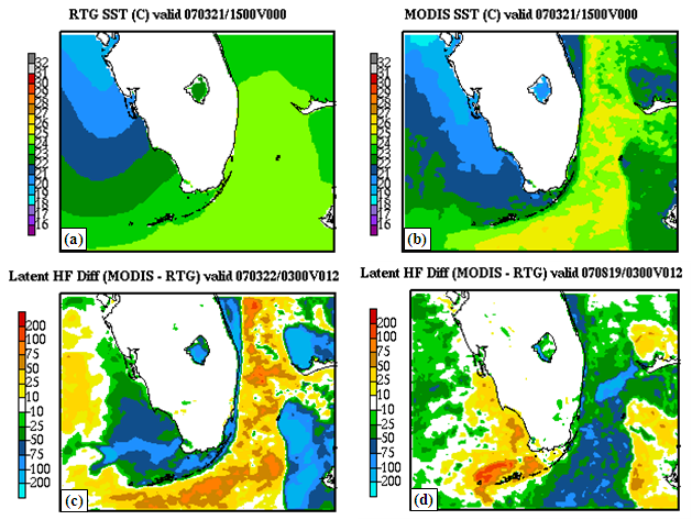
Figure 1. SSTs in the WRF EMS simulation initialized at 1500 UTC 21 March 2007 for (a) the 1/12° RTG SST product, and (b) the MODIS composite. (c) Difference in 12-hour forecast latent heat flux (W m-2) between the MODIS and RTG WRF simulations, valid at 0300 UTC 22 March 2007. (d) Difference in 12-hour forecast latent heat flux (W m-2) between the MODIS and RTG simulations, valid at 0300 UTC 19 August 2007.
These differences in SSTs translate directly into variations in the sensible and latent heat fluxes over the water. The difference in the 12-hour simulated latent heat flux (Figure 1c) shows a reduction of 100 W m-2 or more over the cooler shelf waters near the Florida peninsula and western Bahamas, and an increase of comparable magnitude over the well-defined Gulf Stream region. Such variations in heat fluxes over small distances can lead to simulated mesoscale circulations that may not be resolved by predictions initialized with the much smoother RTG SST field. In Figure 1d, the difference field in 12-h simulated latent heat flux at 0300 UTC 19 August 2007 shows a similar pattern as in the 21 March example, except with the opposite sign in most parts of the domain. Over the shallower waters of the western Bahamas and off the southwest coast of Florida, the MODIS SSTs are warmer than the RTG and surrounding Gulf Stream (not shown), leading to locally highly latent heat fluxes. These results suggest that the MODIS SST composite is better able to capture the regional and (to an extent) seasonal variations in SST gradients, which are closely tied to the relative depths of the ocean around the Florida peninsula, Florida Keys, and western Bahamas.
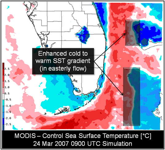
Figure 2. Depiction of SST differences from 24 March 2007 WRF EMS simulation.
Figures 2 and 3 show the impacts of the enhanced SST gradient between the Bahamas and Gulf Stream and how it impacts the modeled surface divergence fields. From the 24 March 2007 simulation on the NWS Miami, FL domain, the SST initialization depicts an enhanced cold to warm gradient as seen in the SST difference field (Figure 2). With the prevailing easterly flow on this day, air flow traversing from the cool waters to the warm waters in the Gulf Stream exhibits an acceleration downwind of the Bahamas, leading to stronger convergence/divergence zones, as depicted in Figure 3. The model runs with the MODIS SSTs subsequently produced enhanced bands of clouds and slightly higher precipitation totals (not shown).

Figure 3. Comparison of low-level convergence downwind of the Bahamas at the 14-h forecast time for the MODIS run (left inset), RTG/Control run (middle inset), and difference (right inset).
Improvements to MODIS-only SST composites
Case et al (2008)
noted that cloud contamination likely led to high SST data latency and reduced performance of the WRF forecasts over
portions of south Florida during June-July 2007. These months experienced frequent convection and widespread cloud
cover, which degraded the quality and increased the latency of the MODIS-only SSTs, resulting in a cold bias in the
SSTs and model forecast 2-m temperatures.
In an effort to reduce product latency and improve the accuracy and representativeness of the SST composite product, an enhanced compositing approach has been developed and implemented by SPoRT to reduce the shortcomings of the past MODIS-only approach. The enhanced SSTs include near all-weather microwave AMSR-E information to improve SSTs during cloudy regimes.
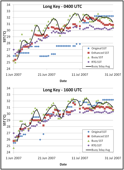
Figure 4. Time series of SSTs at Long Key, FL (mid-Florida Keys) for June and July 2007, comparing the 0400 and 1600 UTC original MODIS-only SSTs to the enhanced SPoRT SSTs, buoy observations and RTG SSTs.
Schiferl et al. (2010) documented the enhancements and resulting improvements to SSTs and model forecast sensitivities surrounding Florida during the time period of high MODIS latencies from June-July 2007. They found that the enhanced, multi-sensor algorithm improved on the bias and error standard deviation, which led to improved sensible weather forecasts in the local model runs. The time-series for the Long Key buoy in Figure 4 indicate that the enhanced SST product (red squares) improved upon both the original highly-latent MODIS-only SSTs (blue diamonds) as well as the RTG SSTs (purple circles). The mean bias decreased from 1.3°C to 0.7°C using the enhanced product. While neither the RTG nor the enhanced SST products followed the nearly biweekly observed SST cycles extremely well, the enhanced product did perform better than the RTG, and both performed much better at mimicking the buoy trend than the original MODIS-only SST composite product. The correlation with the buoy observations improved from 0.69 with the original composite to 0.92 with the enhanced SST composite product (not shown).
Both products were used to initialize a local version of the WRF EMS model over southern Florida. The same WRF configuration, coverage and resolution was used as in the previous SPoRT modeling evaluation conducted over the NWS Miami, FL operational domain (Case et al 2008). The NCEP's Nonhydrostatic Mesoscale Model (NMM, Janjic et al. 2001) dynamical core was run at 4-km grid spacing for 27 hours within the EMS software. The Control model run consisted of the operational WRF configuration as run at Miami, FL using the RTG SSTs. The two experimental runs used the original and enhanced MODIS composite products for the model SSTs. In all instances, the SSTs were held fixed throughout the entire WRF model simulation.

Figure 5. (a) Difference in 0400 UTC SST between enhanced product and original MODIS, and (b) Difference in WRF 2-m temperature for the 9-h forecast valid 1800 UTC 22 June 2007.
The WRF model was initialized at 0900 UTC 22 Jun 2007 for the control (RTG SST) and both SPoRT composite products. This date and time was chosen because of the large SST differences between the three products at 0400 UTC at Long Key, which fits centrally in the forecast domain. Figure 5b shows a 9-hour forecast 2-m temperature difference field (enhanced SST product - original SST product) over the WRF model domain. The enhanced SST composite product produced warmer 2-m air temperatures throughout much of the oceanic region compared to the original SST, due to the warmer model skin temperatures over water (Figure 5a) that caused warming in the corresponding atmospheric temperature in certain areas. This shows an improvement in the ability of the forecast model to produce more accurate results when given the enhanced SST composite values.
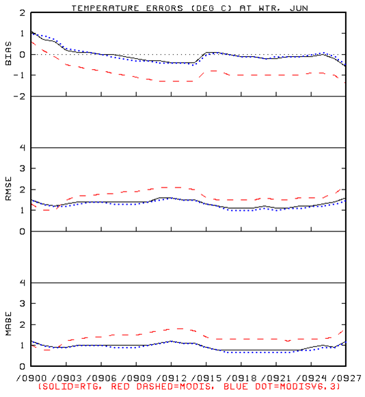
Figure 6. Verification of 2-m temperatures from daily 0900 UTC WRF EMS runs over the Miami, FL local operational domain during 17-30 June 2007, validated at all available buoy/C-MAN locations in south Florida. Statistics shown include the bias (top panel), root mean square error (middle panel), and mean absolute error (bottom panel).
A similar result occurred when considering all of the over-water observations during a period where cloud cover resulted in significant latency in the original SST values. Figure 6 shows the combined, forecast 2-m temperature verification statistics for all of the water sites during the two-week period from 17-30 June 2007 for the 0900 UTC initialization. In this period the original SST values at 0400 UTC used for initialization were noticeably cooler than the observations and were often constant from day-to-day due to cloud cover induced latency. The use of the enhanced SSTs shows the bias, root mean square error and mean absolute error to be nearly equivalent to that of the model runs using the RTG SST, and hence, has addressed the SST data latency issue as well as the SST cool bias. The wind speed bias also improved as a result of a warmer boundary layer and greater mixing of higher wind speeds to the surface. The significance of these results is that the model initialized with the enhanced SST has performed as well as initializations using the RTG SSTs, but the enhanced SST field has retained the mesoscale detail and variations in the SST field as seen by MODIS. This aspect of the enhanced SST product should make it a superior product for use in numerical modeling.
Implementation into WRF EMS version 3
To support the broader operational use of the enhanced SPoRT SST composite product for short term weather forecast
applications, an option to use this SST dataset has been implemented in the most recent version of the NWS WRF EMS
(Rozumalski 2010).
The WRF EMS is a complete, full physics numerical weather prediction package that incorporates dynamical cores from
both the National Center for Atmospheric Research Advanced Research WRF and the NCEP NMM. The system is developed and
maintained by the NWS National Science Operations Officer (SOO) Science and Training Resource Coordinator, Dr. Robert
Rozumalski. More information on the EMS software can be found at the Science & Training Resource Center's WRF EMS Page. The WRF
EMS is available to any NWS forecast office interested in generating their own local model runs, given adequate
computing capabilities. Those interested in using the enhanced SPoRT SSTs must upgrade to version 3 of the EMS to
take advantage of this dataset.
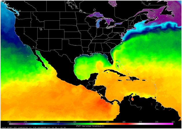
Figure 7. The SPoRT real-time, enhanced 1-km SST composite available in the WRF EMS, depicting the Continental U.S. and Central American domain.
Composites at 1-km resolution covering the Gulf of Mexico, the western Atlantic Ocean, Eastern Pacific, and the Caribbean Sea are generated daily at 0400, 0700, 1600, and 1900 UTC (real-time domain depicted in Figure 7). The enhanced SST composite product is output in gridded binary-2 (GRIB-2) data format for a seamless incorporation into the WRF EMS. The GRIB-2 files are posted online at a dedicated FTP site, which is directly accessed by the WRF EMS.
References Cited
- Case, J. L., P. Santos, M. E. Splitt, S. M Lazarus, K. K. Fuell, S. L. Haines, S. Dembek, and W. L. Lapenta, 2008b: A multi-season study of the effects of MODIS sea-surface temperatures on operational WRF forecasts at NWS, Miami, FL. Preprints, 12th Conference on IOAS-AOLS. January 21-25, 2008, AMS, New Orleans, LA. (abstract online)
- Haines, S. L., G. J. Jedlovec, and S. M. Lazarus, 2007: A MODIS sea surface temperature composite for regional applications. IEEE Trans. Geosci. Remote Sens., 45, 2919-2927.(abstract online)
- Janjic, Z. I., J. P. Gerrity, Jr., and S. Nickovic, 2001: An alternative approach to nonhydrostatic modeling. Monthly Weather Review, 129, 1164-1178. (abstract online)
- LaCasse, K. M., M. E. Splitt, S. M. Lazarus, and W. M. Lapenta, 2008: The impact of high resolution sea surface temperatures on short-term model simulations of the nocturnal Florida marine boundary layer. Monthly Weather Review, 136, 4, 1349-1372. (abstract online)
- Rozumalski, R. A., 2010: WRF Environmental Modeling System User's Guide, NOAA/NWS Forecast Decision Training Branch, COMET/UCAR. (available online)
- Schiferl, L., K. K. Fuell, J. L. Case, and G. J. Jedlovec, 2010: Evaluation of enhanced high resolution MODIS/AMSR-E SSTs and the impact on regional weather forecasts. Preprints, 14th Symp. on Integrated Observing and Assimilation Systems for the Atmosphere, Oceans, and Land Surface, Atlanta, GA, Amer. Meteor. Soc., P535. (abstract online)
- Thiébaux, J., E. Rogers, W. Wang, and B. Katz, 2003: A new high-resolution blended global sea surface temperature analysis. Bull. Amer. Meteor. Soc., 84, 645-656. (abstract online)

